What Are Bulletins and Pesticide Use Limitation Areas (PULAs)?
Stay Updated on ESA Restrictions
As part of its endangered species protection efforts, the EPA has implemented a system of Endangered Species Protection Bulletins and Pesticide Use Limitation Areas (PULAs). These tools provide localized restrictions that applicators must follow to avoid harming federally protected species or their habitats.
Understanding how Bulletins and PULAs work is essential for any retailer, agronomist, or applicator operating in sensitive geographic areas.
What Are Endangered Species Protection Bulletins?
An Endangered Species Protection Bulletin is an EPA-issued directive that outlines geographically specific pesticide use restrictions. These restrictions are often tied to:
- The pesticide being applied
- The target site or pest
- The application method
- Proximity to protected species or critical habitat
Bulletins are legally enforceable and referenced directly on many pesticide labels.
The EPA maintains these through Bulletins Live! Two (BLT) and the BLT Public API — the system where users check for applicable restrictions before performing a pesticide application.
🔗 Official EPA reference:
https://www.epa.gov/endangered-species/endangered-species-protection-bulletins
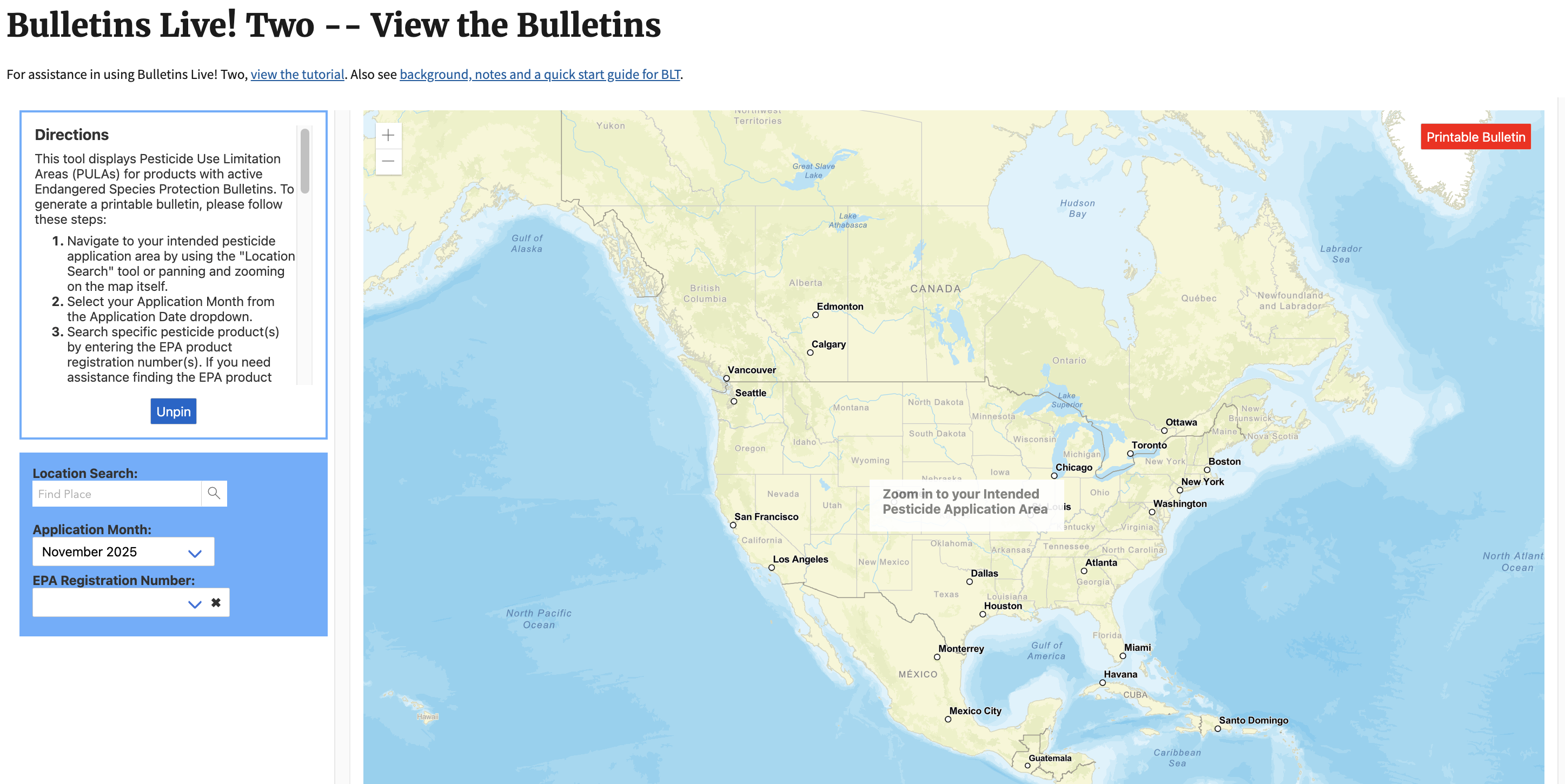
What Is Bulletins Live! Two (BLT)?
Bulletins Live! Two is the EPA’s online portal where users can:
- Look up endangered species restrictions for a specific pesticide
- Enter a location and application date
- View applicable PULA boundaries
- Download the official bulletin for recordkeeping
BLT and the Public API is the authoritative way to obtain real-time ESA compliance restrictions, and it updates regularly. That means applicators must always check BLT at least 6 months prior to an application.
It's important applicators document both when there is and when there isn't a bulletin in the application area for the product they are applying
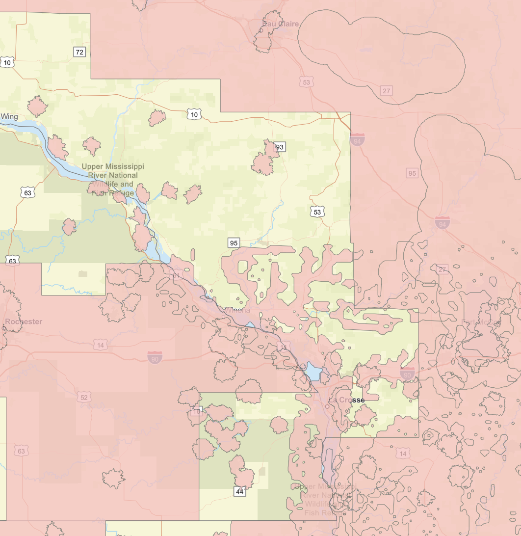
What Are Pesticide Use Limitation Areas (PULAs)?
A Pesticide Use Limitation Area (PULA) is a geographic zone where specific pesticide-use restrictions apply to protect endangered species and their habitats.
Within a PULA, the EPA may require:
- Additional Buffers
- Drift mitigation actions
- Runoff mitigation steps
- Spray timing limitations
- Prohibited date windows
- Restrictions on aerial, ground, or airblast application
PULAs are tied to a pesticide's label and updated dynamically through BLT.
In simple terms:
PULAs = geographic areas with restrictions
Bulletins = the documents describing those restrictions
How Bulletins and PULAs Work Together
The workflow usually looks like this:
- A pesticide label instructs you to check a Bulletin.
- You enter the application location and date into BLT.
- BLT checks whether the area intersects any PULAs.
- If it does, BLT returns all restrictions you must follow.
Because PULAs change, a BLT lookup is required before each application.
Label Language Examples
Pesticide labels include specific language directing applicators to check for Bulletins. The EPA has updated this language over time to clarify requirements and point users to Bulletins Live! Two.
Older Label Language
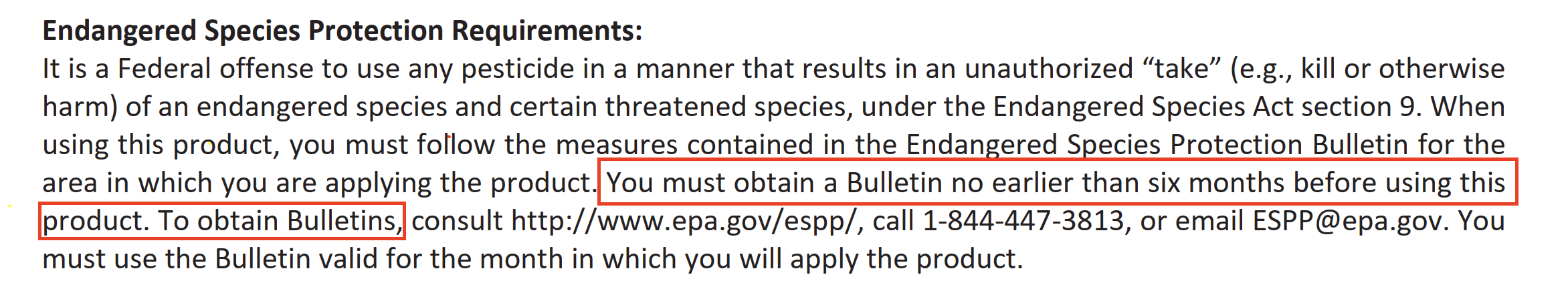
Older labels referenced the previous system and required checking Bulletins "no earlier than six months before using this product."
Updated Label Language
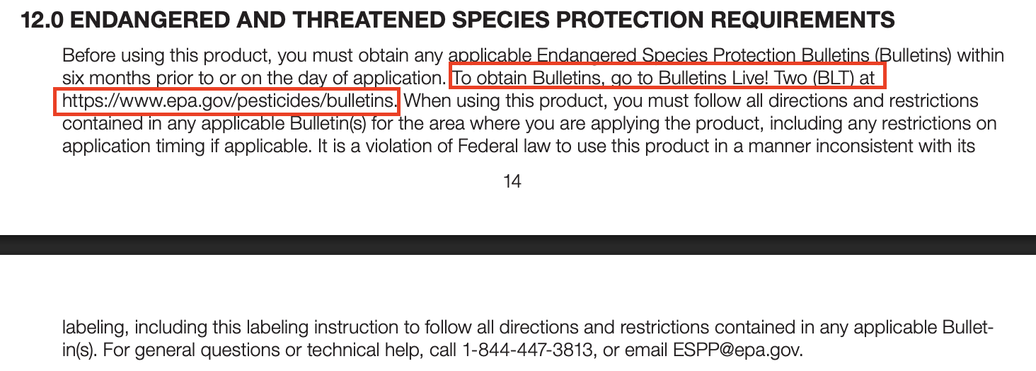
Newer labels direct users to Bulletins Live! Two (BLT) at https://www.epa.gov/pesticides/bulletins and emphasize that Bulletins must be obtained "within six months prior to or on the day of application."
Both versions are legally enforceable, but the updated language provides clearer guidance on accessing the current BLT system.
Maps and Tools for Understanding PULAs
To help visualize these areas, we maintain a national map page that shows:
- PULA boundaries
- States affected by active ESA bulletins
- Areas where additional compliance steps are likely needed
Our interactive map allows you to explore PULA coverage across the United States and get a visual understanding of where ESA restrictions are most likely to apply. This tool is particularly useful for planning applications and understanding regional compliance requirements.
👉 View our interactive PULA & BLT resources map:
Interactive PULA & BLT Resources Map
How We Automate PULA Checks
Our API automatically:
- Checks BLT layers for active Bulletins
- Identifies intersecting PULAs
- Returns all ESA restrictions for the products being applied
- Provides mitigation guidance
- Generates a white-labeled portal link for managing required actions
This reduces manual work and simplifies compliance across labels, PULA locations, and applications.
Summary
Bulletins and Pesticide Use Limitation Areas (PULAs) form the backbone of EPA endangered species protections. With BLT as the authoritative source for ESA restrictions, applicators must integrate bulletin checks into every application workflow.
Using tools that automate these checks reduces risk and ensures consistent, accurate compliance.