Runoff Mitigation Tracking for Growers — Introducing the ESA Field Exchange
Stay Updated on ESA Restrictions
The EPA's Runoff Mitigation Point System Can Be Confusing. We Help Simplify It.
If you've looked at a pesticide label recently and seen language about "runoff mitigation points", directions to check Bulletins Live! Two, or references to the EPA Mitigation Menu, you've run into the EPA's new ESA compliance requirements. The short version: for certain pesticides, you need to hit a specific number of runoff mitigation points before you can spray or record that the field meets the exemption criteria and runoff mitigation isn't required.
This new system isn't going away. More products are picking up these requirements as they are registered or re-registered. So let's talk about what's actually hard about this and how to make it less painful.
The Problem: Too Many Moving Parts
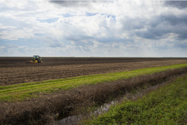
The EPA's runoff mitigation is a points system. Some products require 3 points on the label, some require up to 6 depending on soil type, some require more in specific pesticide use limitation areas for specific crops that exceed the label requirements. You earn points from a combination of where your field is located, what it's like, and what practices you have in place.
Sounds straightforward until you actually try to do it.
You need to know things about your fields that sometimes aren't obvious
To figure out your starting points, you need to know:
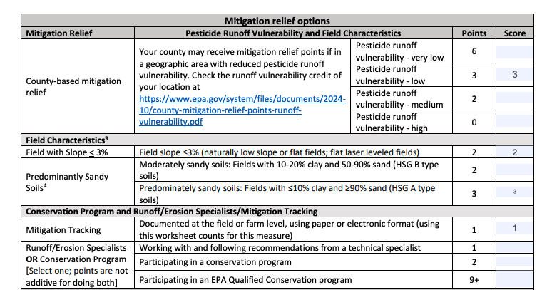
- Your county's runoff vulnerability rating (worth 0-6 points depending on location)
- Whether your field slope is under 3% (2 points)
- Your soil composition — specifically whether you're in Hydrologic Soil Group A or B with the right sand/clay percentages (2-3 points)
That soil information lives in USDA's Web Soil Survey. The county ratings are in an EPA PDF on the EPA Mitigation Menu. You're doing a crossword puzzle just to figure out the baseline for each field.
The points depend on specifics you might not track
Say you've got cover crops. Great — but how many points is that worth?
- Cover crop with tillage: 1 point
- Cover crop, no tillage, short-term: 2 points
- Cover crop, no tillage, long-term: 3 points
Same practice, three different point values depending on details you may not have written down anywhere.
Or take vegetative filter strips:
- 20 to 30 feet wide: 1 point
- 30 to 60 feet wide: 2 points
- 60 feet or wider: 3 points
Did you actually measure that buffer? Do you know if it meets the EPA's minimum specifications for established vegetation?
Your applicator needs this information too — and they're the ones on the hook
Here's where it gets complicated. The compliance burden falls on whoever is making the application. If you hire a custom applicator, they need to verify the points add up before they spray. But most of the points come from things you control as the grower.
Put yourself in the applicator's position. They show up to spray a product requiring 6 points on a field they've never seen before. You're in a high runoff vulnerability county, so you start at zero. The applicator needs to figure out:
- Is this field actually flat enough to claim the slope credit?
- What's the soil type?
- Is that grass strip wide enough? Is it the right kind of vegetation?
- Are you running no-till or reduced tillage?
- Do you have a conservation program enrollment that counts?
They can't just take your word for it — they need documentation. And they need it for every field, every application, across however many growers they're serving that day.
Most applicators don't have time to measure your buffer strip or dig through your NRCS paperwork. So either they skip products with these requirements, or everyone's scrambling to figure it out in the moment.
The Solution: Track It Once, Use It Everywhere
This is the problem the ESA Field Exchange was built to solve.
What it does for growers
When you add your fields to the ESA Field Exchange, the system automatically pulls in:
- Soil types and hydrologic soil groups for each field
- Your county's runoff vulnerability rating
- The baseline mitigation points you qualify for based on location
You don't have to dig through the USDA Web Soil Survey or find the EPA's county list. It's done for you.
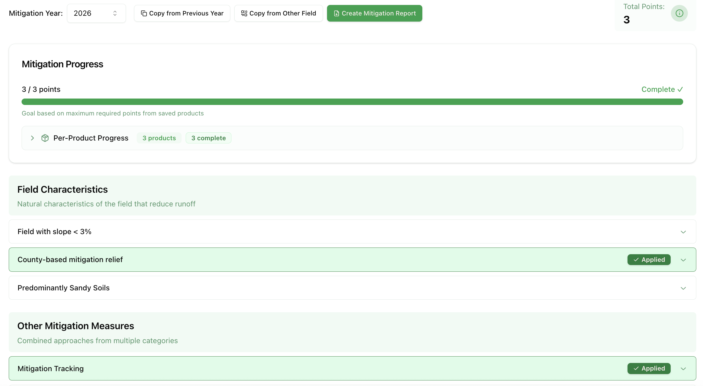
From there, you document which practices you have in place — cover crops, buffer strips, tillage practices, irrigation management, whatever applies to each of your fields. You also input the products you commonly apply to each field. The system figures out how many runoff mitigation points each product requires based on the label and your field characteristics, tracks your point values, and shows you where you stand.
That documentation is worth a point by itself. The EPA Mitigation Menu gives you 1 point just for having "documented at the field or farm level, using paper or electronic format" mitigation tracking. Using the ESA Field Exchange counts.
You can also generate the EPA's Runoff Mitigation Report directly from the platform, pre-filled with your field data. No more filling out worksheets by hand.
What it does for your applicators
Here's where the ESA Check API comes in.
When your applicator uses software that connects to the ESA Check API, the applied mitigations that you've selected are automatically applied to that field and application. Instead of calling you to ask about your buffer strip width or digging through paperwork, they see: "This field has 2 points from county relief + no-till + 40-foot vegetative filter strip."
The applicator verifies the system output, not every individual input. Your attestation to your practices is already in the system. Both of you have a documented record of what was verified and when.
This creates a compliance trail that protects everyone. You documented your practices. They checked before spraying. If anyone asks questions later, there's a record.
ℹ️ Note:
You maintain full control over which fields are enrolled in the ESA Field Exchange. You can opt fields out at any time, and only the fields you choose to enroll will be available to applicators through the API.
A real example
Let's say you're in a county with medium runoff vulnerability (2 points to start). You've got:
- Fields with slope under 3% (2 points)
- No-till corn-soybean rotation (3 points)
- 35-foot grass filter strips on the downslope edges (2 points)
- Documented tracking in the ESA Field Exchange (1 point)
That's 10 points without trying very hard. Most products requiring mitigation points need 3-6, so you're more than covered.
Your custom applicator shows up to spray a herbicide requiring 6 points. They pull up your field in their system, see you've got 10 points documented runoff mitigations, verify the buffer strip is still there, and spray. The whole check takes a minute instead of a phone call and a scramble for paperwork.
Compare that to the alternative: the applicator calls you asking about your tillage practices, you try to remember what you told your crop consultant last year, nobody's sure if the buffer is 30 feet or 40 feet, and the application gets delayed while everyone figures it out, or compliance just doesn't happen at all.
Getting Started
The ESA Field Exchange is free for growers. You can import your fields using shapefiles — if you've got field boundaries from your precision ag setup, you're most of the way there. We can help with bulk imports if you've got a lot of fields to add.
Once your fields are in, you document your practices for each field, and the system handles the point calculations and reporting. When your applicator uses software connected to the ESA Check API, your documented mitigations flow through automatically.
If you're already doing the practices that earn mitigation points — and most growers are — the main lift is just documenting them in one place. The ESA Field Exchange makes that easy and turns your existing practices into verifiable compliance records.
Ready to get started? Sign up for free at acreblitz.com/esa-field-exchange